


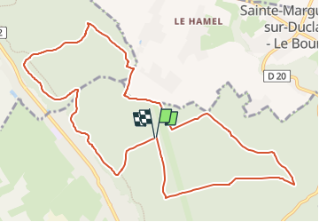
Forêt du Trait- Le Catelier

JMCMoreau
Gebruiker

Lengte
11,9 km

Max. hoogte
125 m

Positief hoogteverschil
217 m
Km-Effort
14,8 km

Min. hoogte
42 m

Negatief hoogteverschil
213 m
Boucle
Ja
Datum van aanmaak :
2022-09-17 14:58:05.379
Laatste wijziging :
2022-09-17 14:59:37.138
3h30
Moeilijkheid : Gemakkelijk

Gratisgps-wandelapplicatie
 SityTrail
IGN / Geografische instituten
SityTrail Plus
De wereld gaat voor u open
Over ons
Tocht Stappen van 11,9 km beschikbaar op Normandië, Seine-Maritime, Le Trait. Deze tocht wordt voorgesteld door JMCMoreau.
Plaatsbepaling
Land:
France
Regio :
Normandië
Departement/Provincie :
Seine-Maritime
Gemeente :
Le Trait
Locatie:
Unknown
Vertrek:(Dec)
Vertrek:(UTM)
341695 ; 5484863 (31U) N.
Opmerkingen